File:Oregon boundary dispute map.png
Oregon_boundary_dispute_map.png (606 × 599 pixels, file size: 106 KB, MIME type: image/png)
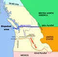
Map of w:Oregon boundary dispute; lands in Oregon country disputed between Britain and the USA. I made the map in Corel Painter IX using information from several maps. No machine-readable author provided. Roke~commonswiki assumed (based on copyright claims). - No machine-readable source provided. Own work assumed (based on copyright claims). CC BY-SA 3.0 File:Oregon boundary dispute map.PNG Created: 30 January 2006
File history
Click on a date/time to view the file as it appeared at that time.
| Date/Time | Thumbnail | Dimensions | User | Comment | |
|---|---|---|---|---|---|
| current | 18:22, 30 September 2019 |  | 606 × 599 (106 KB) | Admin (talk | contribs) | Map of w:Oregon boundary dispute; lands in Oregon country disputed between Britain and the USA. I made the map in Corel Painter IX using information from several maps. No machine-readable author provided. Roke~commonswiki assumed (based on copyright cl... |
- You cannot overwrite this file.
File usage
The following page links to this file:
